By Ma. Cristina Arayata
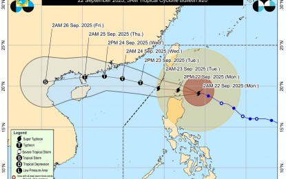
MANILA – Super Typhoon Nando (international name Ragasa) maintained its strength and may pass close or make landfall over Babuyan Islands on Monday noon or afternoon as Tropical Cyclone Wind Signal No. 5 is hoisted in some areas, the Philippine Atmospheric, Geophysical and Astronomical Services Administration (PAGASA) said.
In its latest 5 a.m. weather bulletin, PAGASA said Nando is packing maximum sustained winds of 205 kph near the center and gustiness of up to 250 kph.
It was last tracked 245 km. east of Calayan, Cagayan as of 4 a.m.
Strong to typhoon-force winds will be experienced in areas under Tropical Cyclone Wind Signal No. 5: northern portion of Babuyan Islands (Babuyan, Didicas, Panuitan, Calayan)
Areas under TCWS No. 4 will experience typhoon-force winds: southeastern portion of Batanes (Basco, Mahatao, Ivana, Uyugan, Sabtang), the rest of Babuyan Islands, and the northeastern portion of mainland Cagayan (Santa Ana)
Storm-force winds will prevail in areas under TCWS No. 3: the rest of Batanes, the northern and central portions of mainland Cagayan (Gonzaga, Lal-Lo, Gattaran, Baggao, Alcala, Santo Niño, Lasam, Allacapan, Camalaniugan, Buguey, Santa Teresita, Aparri, Ballesteros, Abulug, Pamplona, Sanchez-Mira, Claveria, Santa Praxedes, Rizal, Amulung, Piat), the northern and central portions of Apayao (Flora, Santa Marcela, Pudtol, Luna, Calanasan, Kabugao), and the northern and central portions of Ilocos Norte (Carasi, Piddig, Vintar, Bacarra, Pasuquin, Burgos, Bangui, Dumalneg, Pagudpud, Adams, Nueva Era, Solsona, Dingras, Sarrat, Laoag City, San Nicolas, Currimao, Paoay, City of Batac, Marcos, Banna)
TCWS No. 2 is hoisted in the rest of Cagayan, Isabela, the rest of Apayao, Abra, Kalinga, Mountain Province, Ifugao, the northern portion of Benguet (Mankayan, Buguias, Bakun, Kibungan), the northeastern portion of Nueva Vizcaya (Diadi), the rest of Ilocos Norte, Ilocos Sur, and the northern portion of La Union (Sudipen, Bangar, Luna, Balaoan, Santol). Gale-force winds will prevail in these areas.
The rest of Nueva Vizcaya, the rest of Benguet, the rest of La Union, Pangasinan, Aurora, Nueva Ecija, Bulacan, Tarlac, Pampanga, Zambales, and the northern portion of Quezon (General Nakar) including Polillo Islands were placed under Signal No. 1 and will experience strong winds.
The southwest monsoon and the trough of Nando are forecast to cause strong to gale-force gusts across Metro Manila, Central Luzon, Calabarzon, Bicol Region, Mimaropa, the Visayas, Northern Mindanao, Caraga, Zamboanga Peninsula, BARMM, Soccsksargen, and Davao Region.
Gale warning is in effect over the seaboard of Northern Luzon and the eastern seaboard of central Luzon.
Meanwhile, there is a high risk of life-threatening storm surge with peak heights exceeding three meters within the next 24 hours over the low-lying or exposed coastal localities of Batanes, Cagayan, including Babuyan Islands, Ilocos Norte, and Ilocos Sur. (PNA)


